Skip to main content Skip to footer

Information Pavilion

Can’t visit the site? The information below is taken directly from the information pavilion on the log chute property. 

What is a log chute?

A log chute is a man-made trough that was used to carry logs over rough river landscape to a sawmill. The concept of the log chute was developed in Canada in 1829 to circumnavigate the Chaudiere Falls in Quebec.

There used to be thousands of chutes around the province and dozens in the county of Haliburton, but they’re all gone now, having fallen victim to time and progress. Some rotted into the landscape; others were deliberately dismantled, burned or replaced with concrete, such as the log chute at Buttermilk Falls which is now only a concrete retaining wall to direct the flow of water.

Log chutes were built by the logging companies that held the cutting rights in the area where the chute was required. When a logging company performed its annual inspection of roads and camps in preparation for the next season, workers would also inspect and repair log chutes. Repairs were made with whatever kind of wood was handy, sturdy, and not valuable. At this chute maple, beech and hemlock were commonly used for repairs.

Log chutes were always attached to dams that were also built by the logging companies. These dams, built of timber crib construction, held back the water until the spring log drives when thousands of logs would be flushed downstream in a mighty torrent.

A log chute was first built here in 1861 and was used regularly until the 1930s by a variety of logging companies that logged the lands around the Hawk, Kennisis, Trout, Crab, Cat and Paint Lakes.

This chute was rebuilt in 1947/48 and underwent extensive repair in the mid 1970s under a federally-funded Winter Works Project. The latest project was started in 1999 and completed in the early 2005. Complete project photos are available at our online Photo Gallery.

Government House

To maintain the dams and check on water levels at Hawk, Kennisis, Trout, Crab, Cat and Paint Lakes required the services of a “damkeeper”.

Travelling by canoe, this man would paddle his circuit and report back the status of structures and levels to the federal government. Big Hawk Road did not exist in the damkeeper’s days, forcing him to travel overland to the waterways.

In 1908 the government built a house for the damkeeper in the bay at the end of this road. By the 1940s it was no longer needed and it was sold for $300. It remains a private home today.

More History of the Chute

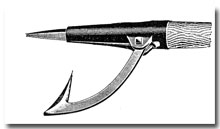
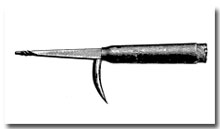
For more than half a century, the logging industry dominated the economic and social life of the Highlands, leaving an indelible mark on the people and the land.

Image shows a man standing on a large pile of logs.

Pine: England’s Prize
Logging had a major impact on the early development of North America. When Britain’s traditional Baltic supplies were threatened by war and political problems, the British navy set its sights on the New World for the squared pine timbers needed for ships’ masts. White pine was prized because of its size and straight, knot-free grain, and because it can be worked easily with hand tools.

North American Expansion
Following the American Revolution, England relied on the forests of Nova Scotia, and then moved on to exploit pine reserves farther west. At the beginning of the 19th century, England was the main consumer of Canadian timber. But as American settlers pushed westward, the United States became Canada’s main trading partner for pine.

White pine was thought to be an inexhaustible resource; so no effort was made to replant what was cut. By the 1870s, the big pines were gone and the squared-timber trade was at an end. The logging industry turned to the production of lumber and sawmills sprang up throughout the province.

Haliburton: A Logger’s Paradise
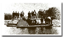
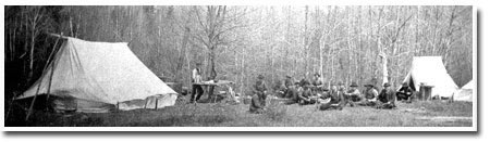
The first region of Ontario to be logged was the Ottawa Valley, where as many as 25,000 men were employed in logging and related industries as early as 1806. In the late 1850s, logging companies moved into the Haliburton Highlands and found paradise.

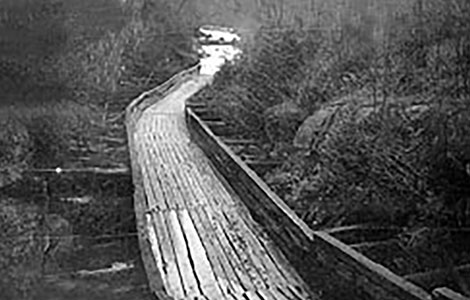
The rugged terrain was covered with massive stands of mature white pine, many trees reaching heights of 250 feet. The region also abounded in red pine, maple, hemlock, spruce, beech, oak, and birch, and yielded about one-and-a-half times that of the Ottawa Valley. Above all, there existed here a ready-made transportation system of hundreds of linked lakes that flowed south and west to lumber mills in Gravenhurst, Bracebridge, Bobcaygeon, Fenelon Falls, and even Trenton.

Size Matters
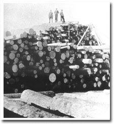
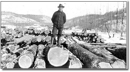
The immensity of the logging operations in this area is difficult to grasp, but records help tell the story. For example, in 1872, the Gilmour Company produced 22 million board feet of lumber in its mill at Trenton, using both Haliburton’s timber and its waterways.

Resources Depleted
In the 1890s, the timber reserves in the northern watersheds became depleted, production declined, and jobs were eliminated. An 1897 American trade tariff resulted in further job losses that had a serious impact on the economy of the Highlands and the counties to the south.

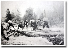
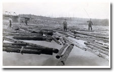
The river drives continued throughout the early 1900s, but on a much smaller scale. The industry began concentrating on sawlogs instead of massive pine timbers, supplying softwood to mills in Gooderham, Haliburton, Minden, Coboconk, Bobcaygeon, Fenelon Falls, and other smaller centres.

The End of an Era
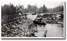
The Gull River in Minden saw its last river drive in 1929. The log chute that was constructed as part of the Orillia Light and Power dam near Minden in 1935 was never used.

The Hawk River saw its last big drive in 1947, when the Hodgson-Jones Lumber Company ran six million board feet to Hall’s Lake. This chute was last used was in 1952.

The logging industry generated a variety of unique tools that served highly specific purposes in the woods, on the river, at the mill, and for moving sawn lumber away. Some of the river-driving tools are still used today in logging, but many are considered antiques to be collected and used for decoration.

Alligator
Peavey
Cant Hook
Invented by a Canadian, this flat-bottomed, amphibious barge could winch itself overland between two lakes, and was used to warp log booms across lakes.
A peavey is a stout, wooden lever about five to six feet in length with a sharp spike on the end and an adjustable steel hook used for turning logs.
A cant hook was a tool like a peavey but it had a toe ring and lip at the end rather than a spike.
Image shows men standing on a wooden boat powered by turbines. Image shows a logging tool with metal spikes affixed to the end of wooden pole. Image shows a logging tool with a metal hook affixed to a wooden pole.
Pike Pole
Caulk Boots
Pickaroon
A 12’ to 16’ pole with a two-pronged end used for moving logs around a river. The straight point was used to push logs, and the curved hook for grabbing and pulling them. Calks or caulks (pronounced “corks”) were sharp, short spikes set in the soles of high, leather boots to prevent the men from falling off logs. A pickaroon was used with one hand to finesse a log into position when a lot of force wasn’t required; broken axes were often made into pickaroons.
Image shows a logging tool with a metal spike affixed to a wooden pole. Image shows a weathered pair of boots. Image shows a tool resembling an axe.


Image shows men guiding logs down a river using poles and spikes. I remember the first morning we went up there to start tailing the Hawk river and I said I wonder how we’re gonna get them logs into the water. You see, I’d never done it before. When we come to the river, this old Sam Whittaker, he had the peavey over his shoulder and he was ahead of us and we were following him like a couple of pups.”
~ Logger, 1947 river drive for Hodgson’s Mill
Loggers use cant hooks and pike poles to push logs through a river in the Highlands ~ Photo: Haliburton Highlands Museum  
Image shows loggers near a dam. “He went into the river up to his neck and started pulling these logs up and that water just ice cold. He was so tough, we just went in, too, and never said a word.”


~ Logger, 1947 river drive for Hodgson’s Mill
McGuire’s drive at Kushog dam, c. 1930s, Stanhope Township ~ Photo: Stanhope Museum  
Image shows men floating on logs and posing for a picture. “Jack Madill could spear a log at Crab Rapids and ride ‘er down to Halls Lake in time for dinner.”
~ Logger, 1947 river drive
“You couldn’t imagine some of the stories these fellas would tell at night up there in that bunkhouse after supper. I remember Ed Mitchell, he’d be sittin’ back and then he’d start with, “There ain’t nothin’ what I ever knowed of …” and then he’d start.. They could keep you spellbound.”
~ Logger, 1947 river drive
Loggers on a drive with pike poles and caulk boots pose for a photo on Big Boshkrug Lake. The bridge in the background is what’s now Hwy. 118 ~ Photo: Stanhope Museum  
Image shows three men standing on top of a large pile of logs. “I remember the food in the camps was excellent. I don’t know how those camp cooks could do it. They wouldn’t have anything but an old stove and bit of a counter and table and they’d put out a choice meal every day.”
~ Logger, 1947 river drive
Logs on a skidway just prior to a dirve, c. 1920s, Stanhope Township. ~ Photo: Haliburton Highlands Museum  
Image shows a lumber camp with white tents.
Overnight camp on a river driver, Haliburton c. 1910 ~ Photo: Haliburton Highlands Museum

Ontario lumber camps played a significant role in the preservation and distribution of folk songs in Ontario. They provided a vivid picture of what it was like to work in the Ontario woods in the latter half of the nineteenth century.

Loggers often made up lyrics that reflected their own camp, fellow loggers and geography. Songs come from as far away at British Columbia, but many are unique to Ontario, from as nearby as Peterborough, Bobcaygeon, Fenelon Falls, West Guilford – even Kushog Lake!

Canadian folklorist Edith Fowke says that despite the hard work, poor pay and lack of creature comforts, songs of the lumbering era were often celebrations of pride in a job well done, camaraderie and good humour.

One of the most widely known songs is The Shantyboy’s Alphabet. It is also one of the oldest, having been traced to about 1904.

The Shantyboy’s Alphabet:

A is for axes that you may all know;

And B is for boys that make them all go;

C is for choppers so early begun

And D is for danger we often stand in.

CHORUS :
‘Tis merry, ’tis merry, ’tis merry are we
No mortal on earth, so happy as we.
A derry, Lo derry, Ring derry dum
Give us shantymen’s grog and there’ll nothing go wrong.

E is the echo that through the woods rang:

F is the foreman, head one of our gang;

G is the grindstone so merrily goes round

And H is the handle, so smoothly ’tis worn.

I is the Iron that mark-ed the pine;

J is the Jov-al that’s never behind;

K is the keen edge our axes we keep

And L is the lice that over us creep.

M is the moss we patch-ed the cracks

And N is the needle we patch-ed our pants;

O is the owl that hooteth at night

And P is the pine that always falls right.

Q is the quarrel we never allow;

R is the river we float our logs down

S is the sleds so stout and so strong

And T is the teams that go jog ’em along.

U is the use we put our teams to;

V is the valley we draw our logs through;

W is the woods we leave in the spring

And this is all I am going to sing.

The language of the logging industry is all but gone today. Below is a sampling of some of the most interesting – and entertaining, terms.

Brush monkey: An entry-level logger; usually the newest member of the crew
Boom: A floating corral of logs chained together.
Buck: To saw a felled tree into short lengths. Bushed: Slightly crazed from being in the woods too long alone.
Calk Boots: Pronounced “cork”; high-cut boots with short spikes in soles and heels for secure footing in slippery logs.
Chickadee: The person who maintains the logging road; also called Road Monkey.
Crazy Wheel: The device anchored at the top of a hill to brake a loaded sleigh down an icy hill in winter (the Barienger Brake).
Cruiser: Person who conducts surveys of timberland.
Crummy: Vehicle used to transport loggers in and out of the forest.
Donkey: Machine used to haul and load logs, powered by steam or diesel.
Drive: The annual spring flush of logs downstream.
Feller: An axeman or sawyer who fells timber by hand.
Gut Hammer: The triangle the cook used to signal mealtime.
Hewer: The broad-axe man who hewed trees into square timber.
Logger’s Smallpox: the scars caused by fights between loggers wearing caulked boots.
Muzzle Loader: An old-fashioned bunk whose only entrance was a narrow opening at the end.
Rosser: The person who peeled the bark from timber before it was squared.
Sandpiper: The person in charge of spreading hot sand on the hill of a winter logging road.
School Marm: A forked tree with two tops.
Turkey: A lumberman’s bag or packsack of clothes
Walking Boss: The person in charge of several bush camps who walked from camp to camp.
Widow maker: A loose limb, top, piece of bark or anything loose in a tree that may fall on a logger.

Haliburton County boasts about 600 lakes, numerous streams and rivers, and countless wetlands. This abundance of water and how it flows across the landscape are explained by the character of the bedrock found in this area.

The rock you see here is mostly metamorphic rock called gneiss (pronounced “nice”), which makes up most of the Canadian Shield. With respect to the flow of water, it is important to note that there is almost no open space within the structure of this type of rock – less than 0.01%! As a result, very little surface water in the Haliburton Highlands seeps down into the bedrock. The well-sealed bedrock bottoms of our lakes and wetlands, keeps the water on the surface instead of allowing it to drain downward.

The bedrock in the Haliburton Highlands is made even more significant by the thin soil cover. Where soil exists at all, it consists of only a very shallow layer on top of the bedrock. Therefore the shape of the landscape here is determined not by mounds of soil, as in other areas, but by the bedrock beneath it. How water makes its way downstream — its flow and speed, as well as the shape of lake basins — are all controlled by the same bedrock topography.

An example of how the bedrock controls the flow of water lies before you. The well-defined valley occupied by the log chute and the Kennisis River was created by two geological events: faults and glaciers.

Faults appeared hundreds of millions of years ago in places where the Earth’s crust cracked and then shifted. As the rock along fault lines moved, it was subjected to a lot of grinding and crushing. As a result, the rock along many fault lines lost its strength and competence and, in many cases, is now broken and jumbled compared to the surrounding rock outside the fault zone.

But how do faults affect the present day landscape? The answer lies with the second event: glaciers.

It is thought that between about 78,000 and 10,000 years ago, most of Canada was covered in up to three kilometres of ice. As this continental glacier ripped and scraped across the landscape, faults became exposed and the glaciers were able to dig deep into the splintered rock along the faults. They removed the fractured, faulted rock and left behind the stronger, unbroken rock. This is how the Kennisis River valley in front of you came to be.

The fault along the Kennisis River valley is lined up with the north-south direction of glacial movement. This alignment allowed the glacier to dig out the faulted rock with great efficiency. The result is this steep-sided gorge.

Much of the topographic variation in Haliburton County can be attributed to the interplay between the glaciers and the broken rock along faults. The resulting cliffs, valleys and soaring uplands throughout Haliburton County presented loggers with great challenges. However, it is also the unique features of the landscape that gave them the vast waterways so desirable for moving timber downstream and sparked the need for inventions like log chutes.

The forest that the first Europeans found here, filled with huge white pines and other species, was very different from the forest we see today. How did this once impressive forest come to be? The answer lies in the history of the landscape before European settlement.

During the last continental glaciation between 78,000 and 10,000 years ago, up to three kilometres of ice ripped and scraped across the landscape, wiping out all established plant life.

But this rocky landscape was a tough match for the glacier and it was only the weakened rock that yielded to the crushing action of the glacial ice. When the ice melted, the broken material dropped out of the ice and created a thin blanket of soil called “glacial till”.

This till was a mixture of boulders, gravel, sand, silt, and clay and not much of it was formed — certainly not enough to cover all the bedrock! That’s why farming in the Haliburton Highlands has never been very good.

In some cases, the glacial meltwater washed the gravel, sand, silt, and clay down into small, low lying pockets in the landscape, but much of the high bedrock uplands and slopes were left barren.

After the glacial meltwaters receded, the barren, rocky landscape left behind was probably close to being lifeless. But even under these harsh conditions, life eventually took hold on the landscape and over thousands of years, the huge white pines, red pines, hemlocks, and other species emerged. The new forests were the result of natural processes and cycles, which were allowed to take their course largely without human interference. However, the trees had enough problems without the loggers being around.

For a huge white pine to grow, for example, a seedling had to overcome a number of daunting obstacles. First of all, wind- or animal-borne seeds had to fall on just the right sandy soil to send down roots and to avoid being eaten by squirrels and mice. The young trees had to survive animals feeding on twigs, bark, and needles. As the trees grew, they had to endure insects, disease, drought, and forest fires. And the taller the trees got, the more vulnerable they were to being blown over by wind and getting hit by lightning.

So how then did the white pines in this area 150 years ago ever make it to heights of 75 metres and diametres of up to two metres? What did the forests have back then that they don’t have now?

The answer is time.

Century after century, an untold number of trees failed in their bid to survive. However, through a natural cycle of trial and error, individual trees succeeded against all these odds. Once the trees survived the ordeals of their youth, they were allowed to just keep growing. Without the ring of the axe and the rasp of the saw, these trees had centuries to achieve staggering heights and widths. In contrast, once the loggers arrived in the mid-1800s, the larger, taller trees were sought and harvested – but never replanted. Once they were cut down, nature’s cycle had to begin again.

The first European explorers encountered forests resulting from 10,000 years of landscape evolution and natural challenges. In fewer than 200 years, human beings changed the forests of southern Ontario with axe and saw. Although the same species are present today, the quantity and distribution of these tree species have changed. Their spectacular history is left to photos and folklore.

Many of the earliest dams in the Haliburton Highlands were built by lumber companies in order to prolong the spring runoff and move logs more easily to their sawmills. In 1905 and 1906 a series of Orders in Council gave the Federal Government the authority to build new dams and reconstruct many others. These dams retained spring runoff in the lakes in order to maintain water levels suitable for both navigation and the generation of electricity from Haliburton all the way to the Trent-Severn Waterway system. At that time, the cottage boom hadn’t begun, and the Hawk Lakes were home to only a handful of hunt camps.

Quality and Flooding
Most of the dam construction and repair work was done in the late 1920s. This concrete dam replaced a timber crib and rock dam during the winter of 1928-29, as shown in these two photos.

As a result of the new and reconstructed dam system, summer water quality improved and spring flooding was reduced. Water was drawn throughout the navigation season, beginning in the uppermost lakes and working down through the storage lakes as more water was needed later in the summer.

Cottage Boom or Bust?
As cottaging developed in the Haliburton Highlands, especially here at the Hawk Lakes, so too did the conflict between the government and the cottagers. The government had the right to draw down water for navigation and power generation, but some years the Hawk Lakes lost up to 12 feet of water, leaving cottagers stranded, docks inaccessible, and boats sitting in mud.

The Debates Begin
During the 1950s and 1960s, extensive correspondence took place among government agencies and cottage associations of both Hawk Lake and Halls Lake. The winch system at this dam was occasionally vandalized and stop logs were damaged by unknown parties seeking to stop the draw down of water.

An Equitable Solution
After many years of debate, a different procedure for drawing water has evolved. Water is drawn from each of the lakes on a equal percentage basis according to the storage range established for that lake. Several times a week, Trent-Severn Waterway staff read water levels at dams and make the necessary log changes ensuring that drawdowns are proportionate. Construction of dam, April 1928. Note the distinct lack of safety equipment and the simplicity of the tools: a saw, an axe, a level and a hammer. Construction of dam, March 1929. The original timber crib dam is beneath the platform at the left.

Sign up for News and Notices!

Keep up to date with everything happening in Algonquin Highlands by receiving regular updates to your inbox!

This website uses cookies to enhance usability and provide you with a more personal experience. By using this website, you agree to our use of cookies as explained in our Privacy Policy.